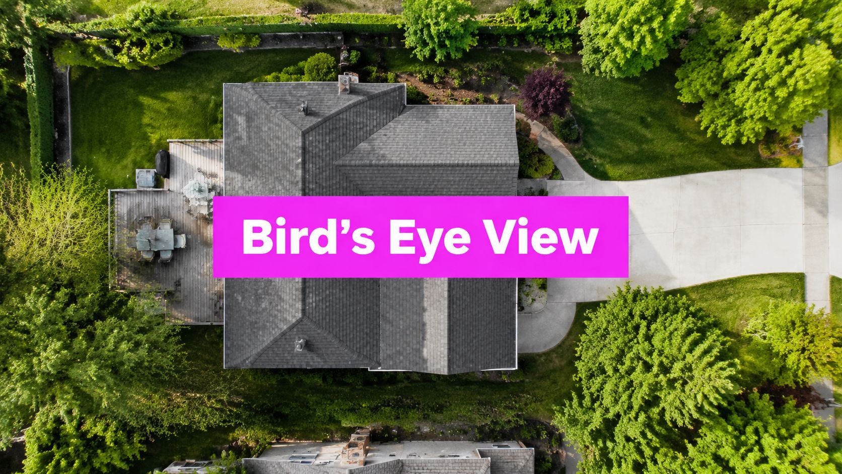
Bird Eye View of a House: Your 2026 Guide

Ryan Bennett • July 12, 2026
Learn how to get a high-quality bird eye view of a house. Compare drones, satellite, 3D renders, & AI for real estate or marketing in 2026.
A listing once landed on my desk with polished kitchen shots, a bright living room, and a front elevation that looked fine. It still felt incomplete because none of the photos showed how the house sat on the lot, where the driveway curved, or how close the backyard was to the water.
Why a Bird's Eye View Sells a Property Faster
Ground-level photography tells buyers what a room looks like. A bird eye view of a house tells them how the property works. That difference matters when someone is deciding whether to book a showing, send the listing to a spouse, or move straight to an offer discussion.

The strongest reason to invest in aerial imagery is simple. Homes featuring aerial photographs sell 68% faster than those without such imagery, according to real estate photography data compiled by RubyHome. In practice, that makes sense. Buyers can judge lot shape, roof lines, setbacks, tree coverage, nearby roads, and the relationship between the home and surrounding properties in a few seconds.
What buyers see from above
An aerial image answers questions that standard listing photos often leave hanging:
- Lot context: Is the yard private, narrow, deep, irregular, or adjacent to busy streets?
- Access and flow: How does the driveway connect, where do cars turn, and what does guest parking look like?
- Exterior condition: Roof shape, outbuildings, pool placement, fencing, and landscaping become easier to assess.
- Neighborhood fit: Buyers can place the house within the block instead of guessing from curb shots.
That matters even more online, where buyers scan fast and compare listings side by side.
Practical rule: If the property's value depends on land, layout, views, privacy, proximity, or site improvements, ground photos alone usually undersell it.
Why this isn't just for luxury homes
A lot of agents still treat aerial visuals like a premium add-on reserved for estates and waterfront listings. That's outdated. Suburban family homes benefit too, especially when the property has a corner lot, detached garage, mature trees, a large backyard, or tricky frontage that doesn't read well from the street.
For marketers building listing campaigns, the aerial angle also solves a content problem. One good overhead or oblique shot can anchor the listing page, social cutdowns, brochure cover, and paid ad creative.
If you're working in a market where drone content is already expected, it's useful to study region-specific examples such as aerial marketing strategies for Florida realtors. The exact tactics vary by market, but the underlying lesson stays the same. Buyers respond faster when they can understand the full property at a glance.
Planning Your Perfect Aerial Shot
The worst time to decide what kind of aerial you need is after the drone operator shows up, the designer starts rendering, or the AI prompts are already generating. Most wasted time comes from fuzzy intent.
Start with the question the image needs to answer. Are you trying to show the full lot? Emphasize a backyard amenity? Clarify a corner location? Make a future build feel real? Each goal points to a different angle, tool, and editing approach.
Choose the view before the method
Many people lump all high-angle shots together, but they do different jobs.
A true bird's-eye view leans closer to top-down. An aerial perspective is usually oblique, showing both roof and facade. The distinction is rarely explained clearly in real estate marketing, even though it changes how buyers read scale and detail. Zillow's early bird's-eye definition referenced imagery captured at a 45° angle, while architectural render workflows commonly use 45° to 60° to reveal more building detail, as described in Zillow's bird's-eye announcement.
That sounds subtle, but it isn't.
- Near-vertical views are better for lot lines, roof layout, and site planning.
- Oblique views are better for marketing because buyers can read both context and structure.
- Too steep and the home can feel flat.
- Too shallow and you lose the site story.
Buyers don't care what the angle is called. They care whether the image answers the question they already have.
Pre-shot checklist that saves rework
Before capture or generation, lock down these variables:
-
Legal clearance
If you're using a drone, confirm local airspace restrictions, property access, and any site-specific limitations. If you're using AI based on a real address, think through privacy and permission before publishing the final image. -
Lighting window
Early morning and late afternoon usually produce cleaner shadows and more shape across roofs, landscaping, and driveways. Midday light can flatten everything. -
Weather tolerance
Light cloud cover often helps. Haze, wind, and wet surfaces can hurt clarity or make a property look less inviting. -
Seasonal intent
Bare trees reveal lot shape. Full foliage adds warmth and privacy. Neither is always better. -
Output format
Website hero image, vertical social crop, brochure spread, and listing thumbnail all need different framing. If you don't define this upfront, you'll compose for the wrong canvas.
A prompt worksheet helps if you're building concepts before production. A simple free AI image prompt generator is useful for translating vague requests like "make it look premium" into clearer visual instructions.
Match the shot to the selling point
If the home's strongest feature is the land, go higher. If it's architectural detail, stay oblique. If the home sits in a dense neighborhood, include enough surrounding context to orient the viewer without making the property feel swallowed by adjacent structures.
Planning isn't glamorous, but it fixes most of the mistakes people blame on the camera, the pilot, or the software.
Choosing Your Method Drones vs Satellite vs Renders
Different methods solve different problems. The biggest mistake is choosing based on novelty instead of constraints. In real projects, the decision usually comes down to speed, realism, control, and how many final images you need.

Drones for real-world accuracy
Drone photography is the most straightforward option when the house already exists and conditions are workable. You get current, property-specific imagery with natural lighting and believable detail. That makes drones the default choice for active listings, especially when the roofline, landscaping, pool, water access, or lot shape adds value.
The downside is logistics. You need the right operator, usable weather, legal clearance, and a clean property on the day of capture. If trash bins are out, the lawn hasn't been cut, or neighboring construction is active, the drone records all of it.
Best fit: existing homes where current reality is the selling point.
Use drones when the property is ready, accessible, and worth showing exactly as it looks today.
Satellite imagery for convenience
Satellite or map-based overhead imagery is the quick fallback. It's easy to source, and for broad location context it can be enough. If an agent needs a simple top-down reference for a lower-priority listing or neighborhood overview, satellite imagery can fill a gap.
Its limitations are obvious once you start using it in actual marketing. The image may be old, seasonally mismatched, lower in practical detail, or framed in a way that doesn't flatter the property. You also have very little control over angle, lighting, and timing.
Here's the short version:
| Method | Strength | Weakness | Best use |
|---|---|---|---|
| Drone | Real, current, detailed | Needs scheduling and conditions | Live listings |
| Satellite | Fast and accessible | Limited control, may be outdated | Context shots |
| 3D render | Full creative control | Requires modeling work | Pre-construction or renovation marketing |
3D renders for properties that don't exist yet
Architectural rendering becomes the strongest option when the home is unbuilt, under renovation, or visually incomplete. You can show a finished site plan, a cleaned-up streetscape, or a future exterior before construction catches up.
In professional 3D bird's-eye rendering, the typical camera height ranges from 30 to 100 meters, with a 45° to 60° viewing angle to balance roof visibility and facade detail, according to Visual Ennode's rendering overview. That range exists for a reason. It gives enough context to read the site while keeping the structure legible.
Renders offer control that photography can't. You can adjust materials, sun position, plant maturity, pavement condition, and neighboring context. But that control comes at the price of setup. Someone has to build or refine the model, source references, align context, and iterate.
Best fit: developments, remodel concepts, entitlement presentations, and marketing before completion.
What works and what doesn't
The practical trade-offs are easier to see in real scenarios:
- A finished custom home on acreage: drone first. Satellite is too generic, and a render adds unnecessary effort.
- A basic resale listing needed tomorrow: satellite may be acceptable for context, but it shouldn't carry the campaign.
- A townhouse project still in approvals: render wins because there may be nothing real to photograph yet.
- A home with messy surroundings: a drone captures truth, which isn't always helpful. A render may clean things up, but it can also feel less credible if overdone.
Satellite is for orientation. Drones are for proof. Renders are for persuasion when reality isn't ready.
No single method is best across every job. The right one depends on whether you need current reality, broad context, or a controlled visual of something that isn't camera-ready.
The AI Advantage for Bulk Aerial Views
The traditional methods above all break down at the same point. They don't scale well when a marketer needs variety.
A social media manager doesn't always need one perfect hero image. They often need a week or month of creative variations. Different crops, different moods, different weather, different ad formats, and sometimes different visual styles for the same property story.

Where AI fits better than the older methods
As of 2025, approximately 22% of all home listings include a virtual tour, which often integrates bird's-eye views, based on Shutterstock's market summary for bird's-eye house imagery. That tells me two things. Demand for advanced visuals is real, and there is still plenty of room for faster, more scalable production.
AI is strongest when the job requires many usable variations instead of one source-perfect capture.
For example, a marketing team might need:
- Seasonal concepts for spring, summer, and fall campaign creative
- Multiple angle explorations before choosing the one that fits paid ads
- Stylized treatments for luxury branding, modern developments, or investor decks
- Fast placeholders while waiting on a drone shoot or render revision
Drones can't generate concept variations on command. Satellite imagery can't be art directed. Renders can be adjusted, but each revision typically depends on a designer's workflow. AI closes that gap by making iteration cheap and fast.
The practical trade-off
AI isn't a perfect substitute for verified, documentary-style aerial photography. If the listing demands exact current condition, exact neighboring structures, or precise legal defensibility, use a real capture method or a well-managed render workflow.
But AI becomes compelling when your bottleneck is production volume.
A branding agency launching campaign assets for multiple listings may need headline images, square social posts, vertical story creatives, and mood-based variants for each one. That is where automation changes the economics of visual production. Teams already thinking about automating agent content creation will recognize the same pattern here. The biggest gain isn't just speed. It's removing repetitive manual setup from the workflow.
AI is the method you use when quantity matters, exploration matters, and waiting on capture logistics costs more than the image itself.
Best use cases for AI aerial generation
A few use cases stand out:
- Campaign ideation: test several aerial styles before committing to a final direction.
- Content batches: generate a library of supporting visuals around a core listing narrative.
- Pre-listing marketing: build teasers before a formal shoot is scheduled.
- Smaller agencies: create premium-looking aerial concepts without hiring a pilot or 3D artist for every property.
If you want a tool built specifically for scalable image production rather than one-off prompting, an AI stock image generator makes more sense than trying to handcraft every image from scratch.
Used well, AI doesn't replace every other method. It replaces the dead space between them, where marketers need more images than the old production models can deliver comfortably.
Composition and Editing Tips for Maximum Impact
A weak aerial image usually isn't ruined by resolution alone. It's ruined by framing, clutter, or editing that fights the property instead of clarifying it.
The fastest quality jump comes from making the image easier to read. Buyers should understand the house, the lot, and the priority feature in one glance.

Start with the angle
Composition matters more than people think. High-quality bird's-eye renders achieve 72% client approval rates when the 45° to 60° angle is maintained, compared with 54% when angles deviate, according to Arcengine's bird-eye visualization analysis. Even if you're not producing architectural renders, the lesson carries over. The angle has to reveal both structure and setting.
Use that range as your working default when the goal is marketing, not surveying.
- Too vertical: you lose facade personality.
- Too low: the image starts feeling like a tall ladder shot instead of an aerial.
- In the middle: the viewer gets roof, frontage, circulation, and site context.
Edit for clarity, not drama
The best edits usually feel restrained.
-
Control highlights and shadows
Lift shadow detail enough to show pathways, side yards, and roof definition. Don't flatten the image. -
Clean up color balance
Lawns, roofs, pavement, and siding should look believable together. Over-saturated greens make everything look synthetic fast. -
Guide the eye
Crop so driveways, paths, fences, or shoreline lines lead toward the home instead of out of frame. -
Remove distractions if appropriate
Temporary clutter, harsh color casts, and edge junk can weaken the image. Keep corrections realistic.
A strong aerial doesn't show everything. It shows the right things in the right order.
Compose for the platform before export
A listing portal, Instagram Reel cover, brochure header, and website banner all crop differently. If you edit a single master image and hope it works everywhere, you'll lose important details in at least one format.
Use separate exports for the main channels. A simple aspect ratio calculator for image crops helps when you're preparing horizontal, square, and vertical versions from one source image.
A few practical habits help:
- For listing pages: keep the house centered with enough surrounding land to explain context.
- For social posts: tighten slightly so the home still reads on a phone screen.
- For print: leave breathing room for text placement if the image will sit under a headline.
- For ads: test crops where the pool, detached structure, or lot shape becomes the focal point.
Editing should sharpen the sales story. If the viewer notices the edit before they notice the property, you've gone too far.
FAQ Getting Your Bird's Eye View
Is it legal to fly a drone over a private house for listing photos
It depends on local aviation rules, takeoff location, airspace restrictions, and how the imagery is captured and used. In practice, agents should work with licensed local operators who already understand the operating rules in that market.
The legal question isn't just "Can the drone fly?" It's also whether the flight path, altitude, neighboring properties, and published imagery create privacy issues. If you're unsure, get local legal guidance before scheduling the shoot.
Is free satellite imagery good enough for a listing
Sometimes, but only for limited use.
If the goal is simple geographic orientation, a satellite view can help. If the goal is to make the property feel desirable, satellite imagery often falls short because you can't control timing, freshness, season, or framing. It works better as support content than as the lead visual.
What should marketers know about AI-generated aerial views of real houses
This is the gray area a lot of articles skip. A critical unanswered question for marketers is the legality of generating AI bird's-eye views of specific houses, because most public discussions focus on stock imagery or drawing techniques rather than privacy and data rules around synthetic visuals tied to real private property, as noted in Wikipedia's bird's-eye view background reference used in this discussion.
That doesn't mean AI aerials are automatically off-limits. It means teams should be careful about how they source reference material, what claims they attach to the final image, and whether the output could imply a level of factual precision it doesn't have.
A safe working approach is:
- Label conceptual visuals clearly when they aren't documentary captures.
- Avoid implying exact current condition if the image is synthetic or heavily altered.
- Review privacy obligations before generating or publishing property-specific imagery tied to a real address.
- Get approval from stakeholders when the image will be used in paid campaigns or listing materials.
If the image is meant to inform a buyer about actual current property conditions, accuracy matters more than convenience.
If you need lots of aerial-style property visuals without the bottleneck of one-by-one production, Bulk Image Generation is worth a look. It's built for teams that need volume, speed, and multiple creative directions, whether you're producing listing support images, ad variations, branded social content, or concept visuals at scale.